
For wildlife rescue and conservation
Drone with AI: free wildlife detection for the DJI Matrice 4
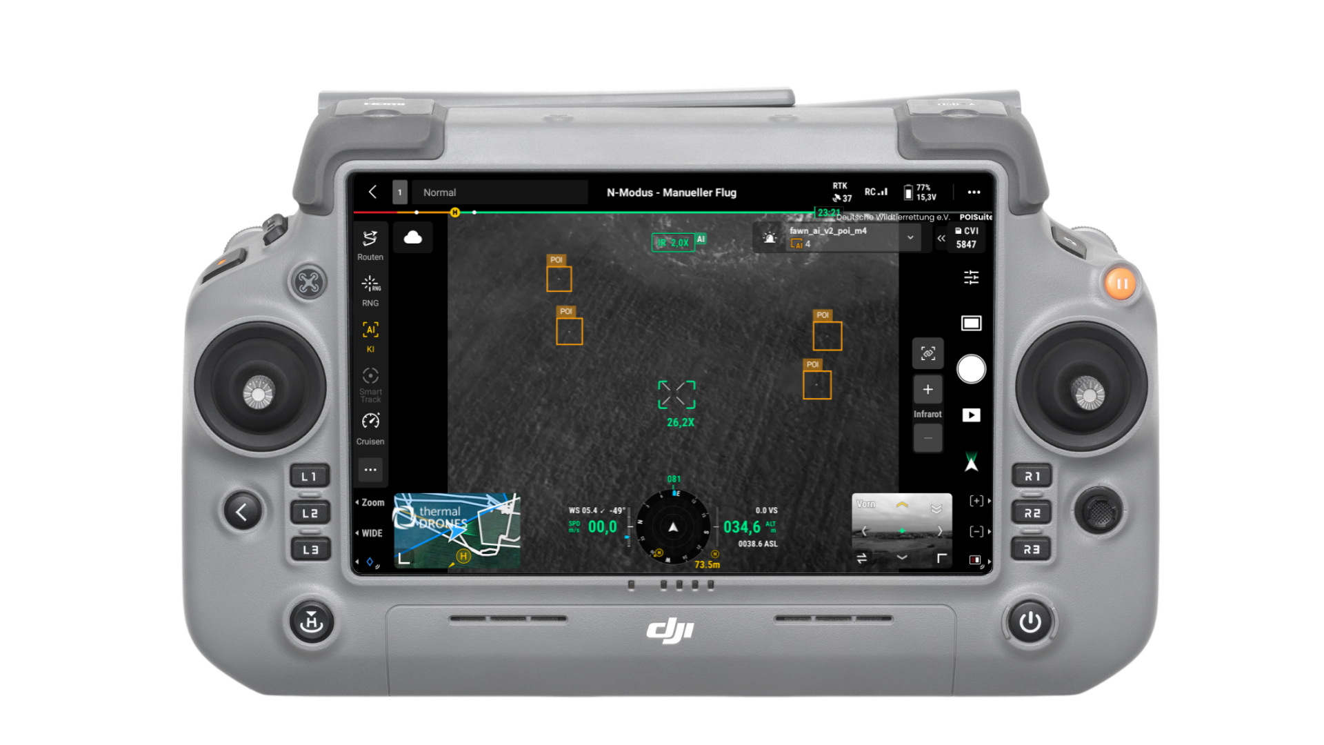
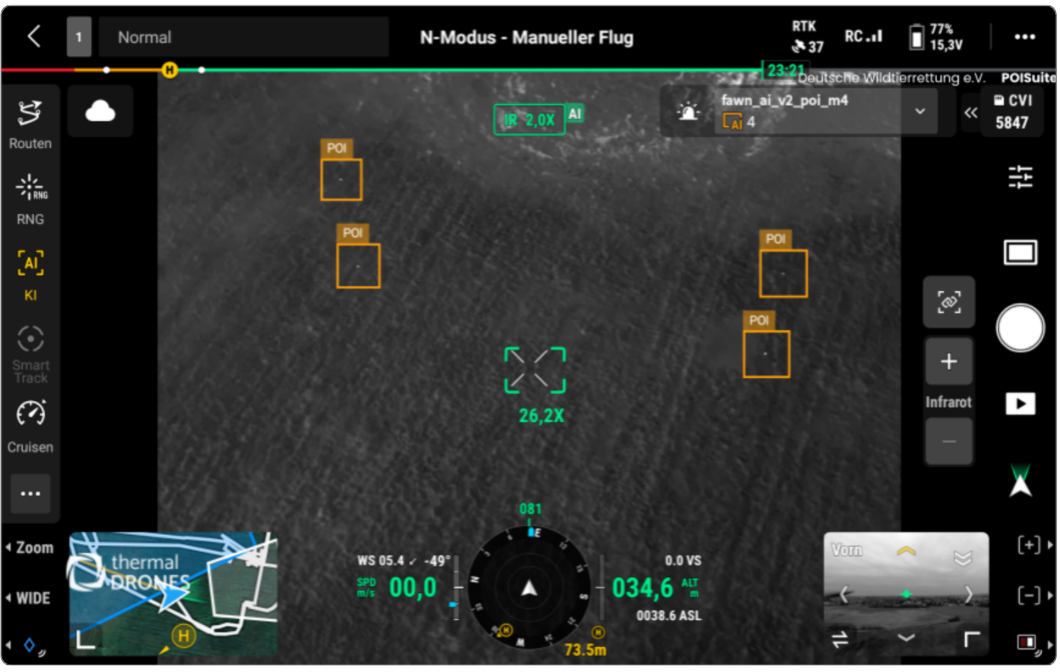
Our AI model runs as onboard AI directly on the drone and detects fawns and the nests of ground-nesting birds in the thermal image while you fly. It is free of charge and available for the DJI Matrice 4T, the DJI Matrice 4TD and the DJI Matrice 400. The DJI RC Plus 2 remote controller shows every detection immediately; you mark it and send it to the POIApp.
The model is a beta version: for testing and learning, not as a replacement for your own eyes on the thermal image.
Beta version: for testing and learning only
If you rely blindly on the AI, you will miss wildlife. Using AI for image analysis costs skill, motivation and attention, and our model is still in development and makes mistakes. Use it for practice, not in a real search before mowing.
For the same reason, each model version only runs for a limited time. You will receive new model generations, and the model stays free of charge.
How AI works on DJI Matrice 4 series drones
With the [DJI Matrice 4T](/en/drones-technic/news-about-drones-technology/dji-matrice-4t/), DJI built an AI computer into a drone for the first time. It runs AI models directly on board, without any additional devices. The DJI Matrice 4TD and the DJI Matrice 400 have this computer too; our model runs on all three.
-
Drone
The onboard AI computer searches the thermal image for fawns and nests
Radio link
-
Controller
The DJI RC Plus 2 frames every detection, you check and mark it
-
POIApp
Helpers on the ground walk to the marked detection
What the AI wildlife detection finds
The model looks for fawns and for the nests of ground-nesting birds. We trained it on more than 100,000 thermal and colour images from real fawn rescue and bird protection missions. Our customers provided these images over several years.
The AI recognises patterns, not animals: it compares the pixels in a new image with what it knows from the training images and states how likely a match is. It does not understand what it sees.
AI also helps with the analysis on your computer: how POIStudio finds fawns in thermal images is explained on our page about AI for drone-based fawn rescue.
Install the AI model in three steps
- Create a POICloud account. Register in the POICloud and start the free trial. If you already have an account and your drone is registered there, go straight to step 3.
- Register your drone and remote controller. Switch both on and connect them to the internet. In DJI Pilot 2, tap Cloud Service, choose Open Platform and log in with your POICloud account. We then activate the model for your drone’s serial number. This takes about one day.
- Download the model and load it onto the drone. Download the matching model in the POICloud on the remote controller; you can ignore error messages during the download. In DJI Pilot 2, open the AI model management, tap the plus sign in the algorithm details, import the ZIP file from the Download folder on the memory card and, with the drone switched on, load the model onto the drone. The guide to using the AI (PDF, German) shows every step with screenshots.
Set up the thermal camera and the AI correctly
- Switch on inspection mode: In the thermal view, tap the icon with the three sliders, then the three dots at the top right, and select inspection mode under Scene. One level up, switch off the UHR infrared image.
- Select White Hot: Use the colour palette at the top right to activate White Hot. The model is trained for inspection mode and White Hot; without both, it detects nothing.
- Activate the AI: Tap AI in the sidebar on the left and select the POI AI model in the intelligent algorithms menu.
- Set the confidence level to 65 %: This is a good starting value. If it is too low, the AI reports many false detections; if it is too high, it misses young animals. You will find the right value for your conditions with experience.
- Use inspection mode with care: It maps the sensor readings linearly to brightness. This makes fawns stand out well in cool grass. But if there are warmer and larger objects in the image, such as the doe, manure heaps, vehicles, people, ditches, stones or roads, you can miss animals.
Flight parameters for AI detection
| Target | Flight altitude | Speed |
|---|---|---|
| Fawns | 60–70 m | 5–7 m/s |
| Ground-nesting birds such as lapwing and grey partridge | 40–45 m | 4 m/s |
Point the camera straight down (gimbal at −90°); the model has not learned oblique views. At these altitudes, each animal covers about 9 to 16 pixels in the image. With fewer pixels the AI lacks information; with considerably more, the pattern no longer matches a wild animal.
How to plan altitude, track spacing and speed for the whole area is explained in our article on the optimal drone flight parameters for fawn rescue.
Where the AI reaches its limits
The model is trained for fawn rescue and only works under the conditions in which those flights take place: over meadows, early in the morning, with the camera pointing straight down. If you do not stick to the settings and flight parameters, it detects nothing.
Difficult: solar radiation, uneven vegetation and warm surfaces such as water and ditches.
Not trained: arable land, forest and, for now, sunshine.
The biggest hurdle is not finding animals but sorting out false detections: mounds of earth and fence posts can look like a fawn in the thermal image. The AI grasps no context, it only calculates probabilities. A detection on the remote controller is therefore always a hint that you check yourself.
A joint project: contribute training images
This model exists because fawn rescuers and conservationists have trusted us with their images for years. Many thanks for that! The more images, the fewer false detections. If you want to help, take these images of every scene and save all photo types:
WIDE: wide-angle colour and thermal image
ZOOM: telephoto colour and thermal image at exactly 7.1x zoom
Take photos at flight altitude and lower as well if you like, of animals as well as false detections. The drone model does not matter. You can upload the images directly via the POICloud interface: tick the box for AI improvement there.
Frequently asked questions about AI for drones
How much does the AI model cost?
Nothing. The AI model is free and stays free in new versions too. To have it activated, you need a POICloud account in which you start a free trial.
Which drones is the AI available for?
For the DJI Matrice 4T, the DJI Matrice 4TD and the DJI Matrice 400. These drones have a built-in AI computer on which the model runs. Which drone suits your work is shown in our overview Which drone is compatible with POICloud?
How long does activation take?
As soon as your drone and remote controller are registered in the POICloud, we activate the model for your serial number. This takes about one day. You can use the waiting time to try out the POICloud.
How long can I use a model version?
Each version only runs for a limited time, because we do not want a beta version to end up in real operations. You will receive new model generations, also free of charge. They too are meant for testing, not for real operations.
Can I rely on the AI during fawn rescue?
No. The AI is an additional aid that you learn and test with. Keep scanning the thermal image yourself: if you rely on the AI, you will miss animals.
Does the AI work in sunshine, on arable land or in forest?
Not at the moment. The model only knows meadows under the cool early-morning conditions typical of fawn rescue.
Read more